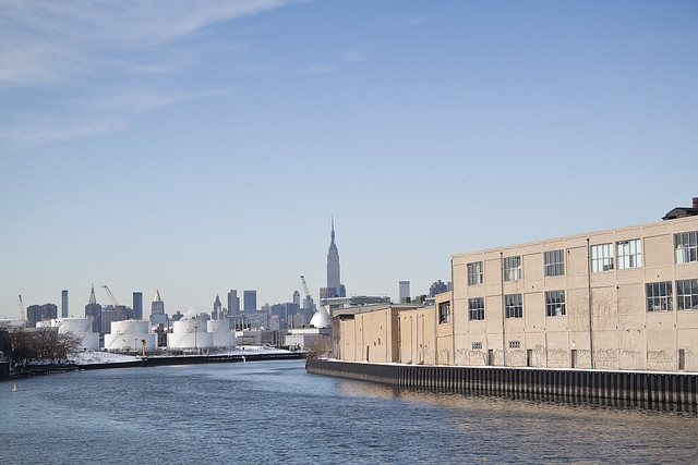
- photo by Mitch Waxman (February 16, 2009)
Sadly, oil is seeping out of a bulkhead on the Queens side of the Newtown Creek.
Famously, the Greenpoint Oil Spill
(click here for a link to newtowncreekalliance.org for more) occurred just across the water from this spot, but every indication points to this as being a separate event. The former site of Charles Pratt’s
Queens County Oil Works, which was an approximately 18 acre parcel which would later be called the “Standard Oil Blissville works”, the sites occupation in modernity has little or nothing to do with petroleum.
Welcome, by the way, to Newtown Creek- and to the “Blissville Oil Spill”.
Just a note: For the purposes of this posting, I’m departing from the normal formatting, and the photos are presented along with the dates upon which they were captured.
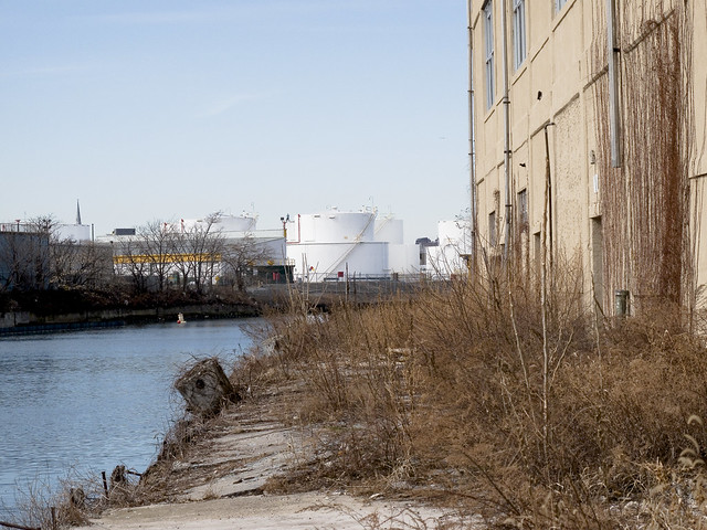
- photo by Mitch Waxman (September 14, 2008)
My practice for the last several years has been to shoot everything I see along the Newtown Creek, whether or not it seems significant at the time. This practice evolved out of the paucity of photographic documentation of the place which survived the 20th century, and the effort has been made with the notion of leaving behind something for future researchers to work with. As time has gone by, and my technological capabilities have expanded, I’ve developed quite a library of shots.
The photo above depicts the site in question during the autumn of 2008, and shows the historic condition of the bulkheads.
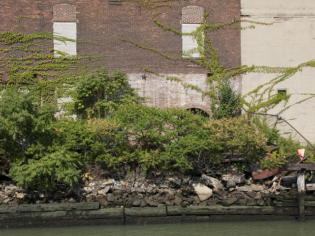
- photo by Mitch Waxman (September 14, 2008)
A standard codex for interpreting what one sees along the Newtown Creek states that wooden bulkheads are 19th century, reinforced concrete dates from the early to mid 20th, and steel plating is late 20th and early 21st century. This rule is not “scientific” but allows one to approximate the manufacture of these fallen docks to a relative time period. As you can observe in the shot above, the risible decay of the wooden bulkheads, and their manner of construction, speak to a long period of disuse and lack of maintenance as far as September of 2008.
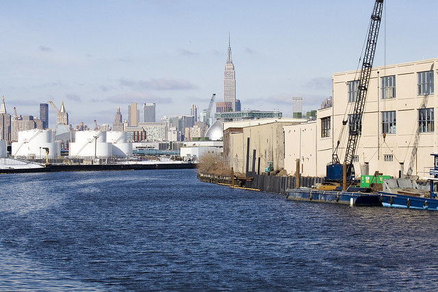
- photo by Mitch Waxman (February 20, 2010)
In the winter of 2010, a crew began to install modern steel plating along this frontage, which drew my interest. Again, anything that is in a state of flux along the waterway is a point of interest for me. This project went on for several months, and was conducted from a barge with a small crane installed on it.
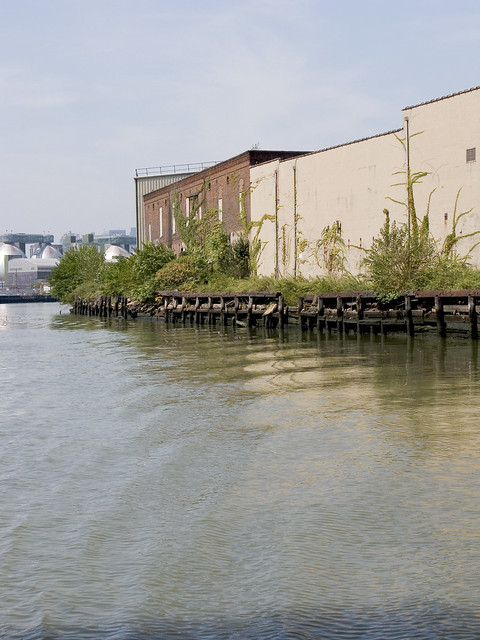
- photo by Mitch Waxman (February 4, 2011)
By the same period a year later, in February of 2011, the modern installation was complete. Conflicting reports on this style of bulkhead are often heard. The older wooden structures offer a structure for biological organisms to nest and shelter, but “slow” the already tepid flow of water through the narrow passages of the Creek. The steel ones “quicken” the flow, but offer no toeholds for organic life.
Modern day,
(December 2011) google maps screen capture,
click here or the image above for the dynamic google map. This is an industrial cul de sac today, accessed by a private driveway. The companies which use this space are largely waste management oriented, warehouse operations, furniture refinishing, or other truck based businesses. Despite the presence of freight tracks through the middle of the site, few of these companies utilize their sidings. Calvary Cemetery and the Kosciuszko Bridge loom large and distinguish the area.
The oil tanks in the center of the site betray the presence of the “Queens County Oil Works” of Charles Pratt, which were also known as the “Standard Oil Blissville Works”. Blissville, of course, is the historic name of this part of Queens which was once a residential area.
Detail view of the area,
click here for larger incarnation. The works were here as late as 1951, but at this point, I still haven’t been able to confirm the date they were closed down.
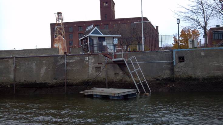
- photo by Mitch Waxman (August 6, 2011)
In the summer of 2011, I was tasked with photographing a “Bulkhead Survey” which members of the Newtown Creek Alliance were conducting. The good folks at Riverkeeper volunteered to take our party out on the Newtown Creek onboard their patrol boat, and when we were passing by the former Queens County Oil Works, we noticed the presence of both containment booms on the water and petroleum product flowing freely from the shoreline itself.
- photo by Mitch Waxman (August 6, 2010)
The theory which has been advanced by knowledgeable sources is that when the steel bulkheads were installed, a process in which the plating is slid down into place and then secured, and that a sealed chamber or buried pipeline was likely ruptured during the construction process which freed “the product”.
I have been asked to mention (by Newtown Creek Alliance and Riverkeeper itself) that investigation of the situation is underway, and the State and City officials responsible for policing this sort of thing are fully and enthusiastically engaged in the process.
- photo by Mitch Waxman (August 6, 2010)
The story of Charles Pratt, his “Astral Oil”, and their involvement with John D. Rockefeller’s Standard Oil Trust will be discussed in a later posting on this subject, as the lengthy history would divert attention from this otherwise serious issue. Suffice to say that the Blissville works were some 18 acres in size, and suffered several “total loss” fires in the late 19th century.
Note that this is a distinct property
(and event) from the adjacent State Superfund site which is referred to as
the Quanta Resources site.
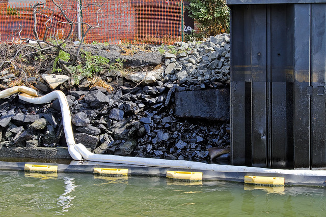
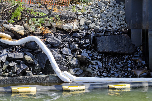
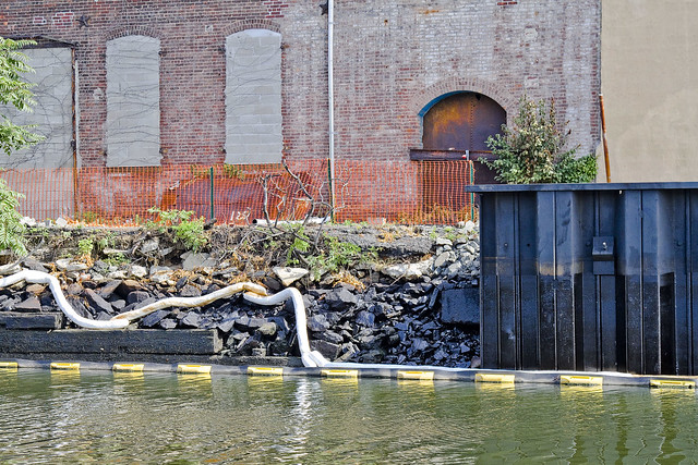
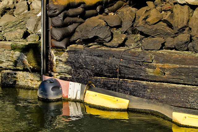
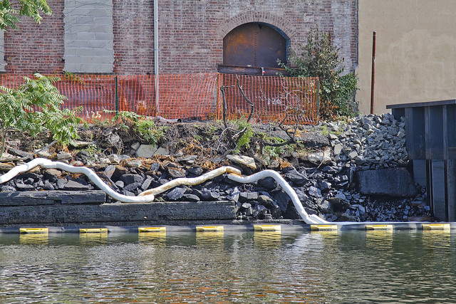
- photo by Mitch Waxman (November 19, 2011)
Again onboard a Riverkeeper patrol, this time in November of 2011, the overt visual presence and subtle aroma of petroleum was encountered. The black and yellow structure is what is known as a hard boom, and is designed to contain surface contamination and “floatables”. It extends to a few inches below the surface.
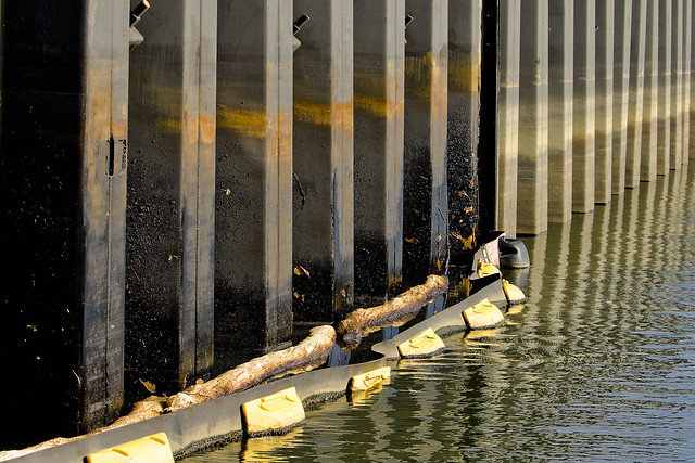
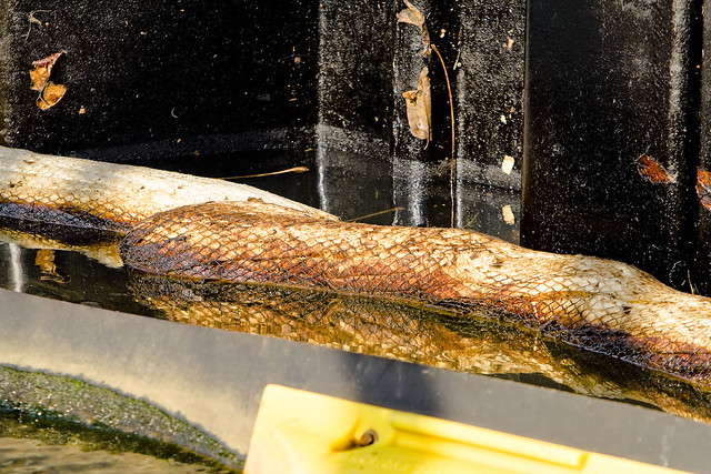
- photo by Mitch Waxman (November 19, 2011)
The steel plating at the site is painted with oil, undoubtedly splashed up by wave action during storms at high tide. The white objects which are saturated with petroleum products are absorbent booms, designed to wick up the free floating product.
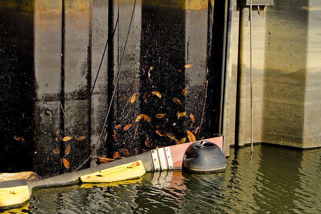
- photo by Mitch Waxman (November 19, 2011)
The leaves in the shot above are literally stuck into the gluey residues of the oil. You can see the high tide mark left by the water on the cleaner bulkhead which is just beyond the hard boom. Perhaps this is the source of oil, which many have reported to me over the course of the last year, which has been witnessed as it floats toward the East River.
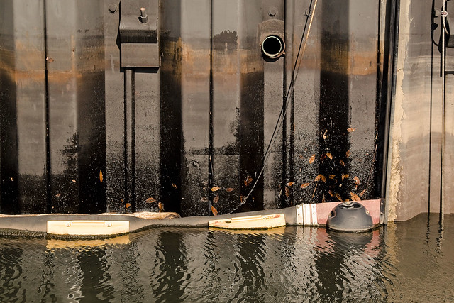
- photo by Mitch Waxman (November 19, 2011)
It is not news that there are environmental contaminants floating freely in this troubled waterway, nor is there any revelation to be found in the fact that petroleum products are commonly observed pooling and flowing about the Newtown Creek watershed.
What is news is that this is in Queens.
- photo by Mitch Waxman (August 6, 2011)
Much of the attention, and deservedly so because of the large and growing population of Greenpoint and Williamsburg, which Newtown Creek receives is all about Brooklyn. The north shore of the Creek in Queens is often left out of discussion (and from both remediation and environmental benefits funding) because of its relatively tiny population and industrial character. One of the questions which this blog has asked since day one has been “Who can guess all there is, that might be buried down there?”.
In the case of the Blissville Oil spill, the question might as well be “How much there might be?”.
- photo by Mitch Waxman (November 19, 2011)
This is just the beginning of a new Newtown Creek story, the tale of the Blissville Oil Spill. I fear it will be the first of many such stories, as we move into the Superfund era.


