Showing posts with label waterfront development. Show all posts

Tuesday, September 27, 2011

Beacon Sewage Overflow

Raw sewage is flowing into the Beacon Harbor from a pipe at the northeastern corner of the harbor.

A member of the public called this sewage release into Riverkeeper's office on Saturday, September 17. Riverkeeper investigated the report, documented the discharge and called it into the NY State Department of Environmental Conservation (DEC) and authorities in the City of Beacon on Sunday, September 18.

Riverkeeper sampled in the area of the discharge on September 23. That sampling confirmed very high sewage levels (>24,196 per 100/ml, the highest our system can read). Based on this data, and the lack of public notification for this ongoing release, today we issued a press release strongly advising the public to avoid contact with the water in Beacon Harbor until the source of the spill has been fixed and testing confirms that water quality has returned to acceptable levels.


Video showing the flow rate of the spill
The blue color of the water is typical for sewage spills

The water is flowing out of this spillway and into the harbor

This is the view of the harbor with the source of the sewage overflow behind you

Debris that appears to be toilet paper clings to the branches of shrubs next to the overflowing pipe
Learn about our push for a Sewage Right to Know Law for New York State
See our historic water quality data for Beacon Harbor

Sunday, April 20, 2008

Early spring debris- natural & manmade

We've had days of very high spring tides and no wind so an amazing amount of debris has floated off the riverbanks. It's all still out here because there hasn't been any wind to sweep it all ashore again.

I find many of these blue plastic 55 gal drums. They are extensively used as floatation for floating docks at boat clubs and marinas. This one is empty and light but full ones are very heavy.


A massive new structure under construction just south of Norrie Point at Hyde Park.
I'm told that this is a private residence. A lovely small home stood here until last year which was almost entirely hidden by trees.


Catch of the day from Kingston to Nyack. Totals for the six day patrol:

9 - Tires with metal rims attached
5 - plastic 55 gal drums
1 - 1 gal plastic bottle 1 - 2'x4' plastic/foam sheet 20 cubic feet dock styrofoam
4 - party balloons
5 - plastic drink bottles. Passed hundreds more.
1 - boat fender
1 - 5 gal plastic cooler
1 - 3 gal steel Freon tank
1 - soccer ball
1 - 2 gal plastic bucket 1 - duck decoy. He's my friend.

More floating debris. "All natural" this time. Looking south toward Blue Point beyond the Poughkeepsie Bridges. This is why I don't like to run at night.


Looking south toward Storm King. Spring at the bottom but still winter at the top.


Friday, April 18, 2008

Albany Observations

A new abandoned wreck just at the south end of Albany's Corning Preserve. It is very difficult to find any state or municipal agency which will get involved in cases like this.

Intake structure at Bethlehem Energy Center. No gunderboom screens have been rigged this year as required by their permit. Shad and herring spawning is taking place now. I've notified DEC Fisheries Unit.

New construction just south of Albany where a smaller home existed before.

Thursday, April 17, 2008

Observations: Kingston to Castleton

Rondout Creek patrol early morning. Looking east at the CSX RR bridge. I don't go under the bridge when there is a train crossing. Chicken.

A flexible hose, like fire hose, has been led down the south bank of Catskill Creek from the area of the swimming pool at Forlini's Resort. We saw this hose coiled at the top of the slope several years ago. I investigated and found that the resort had closed. Now the hose has been deployed, presumably to pump out the pool.

At this time it may just be water which accumulated over the winter but it indicates that the resort may be reopening and we will have to warn them about discharging chlorinated water pool later in the season.

The smaller black suction pipe visible near the fire hose is probably used to suck up creek water for use at the resort. Catskill Creek is a spawning ground and home for a number of fish species.

Between Catskill Creek and The Rip Van Winkle Bridge on the west bank and straight across from Olana. Visitors to Olana get this view looking west. Another case of "Too bad sucker, I've got my beautiful view and to hell with yours". Good thing Frederic Church isn't round. He might go postal.

A very well established camp on Primming Hook on east bank north of Hudson. All the building materials were brought in by boat. This is prime habitat. To the north is a Scenic Hudson marsh. To the south is Open Space Institute land at Hudson. To the east is the Amtrak rail line. Clearing the camps (this is one of two) and adding this parcel to the surrounding preserved area would be great.


Eroded bank at Castleton Boat Club. In the past the club used waste cement test cylinders, spent machinery and extra building materials as fill and we warned them about the illegality of doing so again.

Erosion over the winter has exposed tires buried sometime in the past as fill. Very tidy stacking. How many tires are buried at the site? How much and what other kinds of waste material were buried?

An active Bald Eagle nest with kayakers below. Moments after I took this photo the eagle swooped down and attacked one of the kayakers. (Just kidding!)

Tuesday, April 15, 2008

Observations: Newburgh to Poughkeepsie


Northbound on 1st patrol to Troy this year. Flat ass calm in Newburgh Bay. Looking south at Storm King and the northern edge of the Highlands. Bannerman's Castle on the left.


High School rowing teams at Newburgh. Youth and adult rowing is getting more and more popular. There are clubs and teams at a number of locations on the river from NYC to Albany.

Clearing ground at the south end of the Poughkeepsie waterfront. This area was wooded. Now all the trees have been knocked down with heavy machinery. Across the river is a beautiful high ridge above Blue Point preserved by Scenic Hudson. No one seems to want any trees blocking their view.

Wednesday, April 11, 2007

Pollution and sprawl appear along our shores

Photos by John Lipscomb4/11/07: Development in Middle Hope just north of Newburgh. There is a wetland on other side of the tracks. This is a perfect example of sprawl and poor land stewardship. We’ve been monitoring this development for three years but there has been no clear violation of the Clean Water Act.


Continued up to Poughkeepsie at Clinton Point with a Pace student to investigate a quarry owned by Tilcon. This is the 3rd student to work on the case. We are contesting the DEC’s permits for discharges into Hudson. This delta creek contains stone dust and gravel.


Stopped at site of new house construction between Manitou at Garrison. For some reason the builder decided to throw the demolition debris into the river – we are proceeding with enforcement.
Patrolled at Tomkins Cove and the Lovett Power Plant. Took some pictures of their yellow gunderboom which is a fish and larvae excluding curtain. This kind of set up is a poor substitute for closed cycle cooling. The gunderboom is open at the north end which entirely defeats the purpose of the boom. We have an attorney working on the case.

Friday, July 07, 2006

Rain brings turbidity & pollution for the river


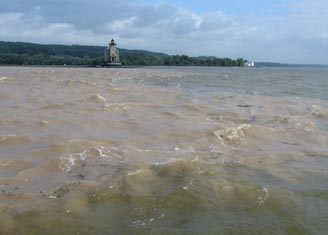
Record heavy rains fell on June 26, 27 and 28 during our June patrol to Troy causing massive erosion in the watersheds of several Hudson River tributaries. In one photo you see the brown flood blowing out into the Hudson at the Kingston Lighthouse on Rondout Creek. The other shows the Hudson tinted red/orange from sediment flushing out of Esopus Creek at Saugreties. The flood also carried out a tremendous load of plastic trash which will litter the shoreline for years to come.

It was interesting to see that tributaries flowing through undisturbed countryside still ran clear in spite of the deluge - with no sediment load from erosion. Most erosion is due to overdevelopment, road construction and impervious surfaces - sprawl.